| As high-altitude jet traffic increased by the 1980’s, aircraft capacity in the upper airspace became crowded, particularly between 29,000 feet and 41,000 feet — the altitude band preferred by airlines for fuel economy. However, the lowered air density above 29,000 feet caused traditional pressure altimeters to be less accurate. While aircraft flying below 29,000 feet could be safely separated vertically by 1,000 feet, aircraft flying above that altitude were required to maintain vertical spacing of 2,000 feet. New altimeter technology introduced in the 1990’s produced significant improvements in altitude measurement and led to the worldwide introduction of Reduced Vertical Separation Minima (RVSM), which allowed aircraft to be vertically separated by the normal 1,000 feet at altitudes up to 41,000 feet. However, while all aircraft intending to operate in RVSM airspace were re-equipped to meet the new requirement, it was necessary to initially verify and periodically check that the new equipment installations were operating within stated tolerances. Multilateration was chosen as the best technique to perform this task and purpose-built systems were installed and are still operating at various points around the world. The addition of flight levels at the most fuel efficient — and thus most popular — cruising levels means traffic flows can be more flexible and offer reduced congestion and fuel consumption. | | 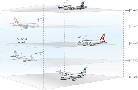
Mulilateration-based HMU systems have been deployed for RVSM at various locations around the globe.
"En-route WAM systems can also provide accurate height measurement information which is not available from MSSR.” Wide Area Multilateration Report on EATMP |